Bartram Trail: Wallace Branch to William's Pulpit- Franklin, NC
Categories: Hiking & Backpacking
Highlights
- Part of Section 4 of the 100-mile N.C. Bartram Trail
- Steady climb up the ridgelines and peaceful forests
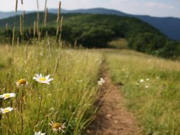
- Spring and Summer wildflowers along trail
- Cascading Waterfall within 5 min. of parking area
- Views of Mill Creek Country Club and Valley from 100 ft. long rock shelf
- Yellow Blazed trail
The Local Scoop
The N.C. Bartram Trail runs for approx. 62 miles from vista to valley up from Rabun County, Georgia and into the Little Tennessee Valley South of Franklin and Northwest of Highlands. The entire trail from Russell Bridge (Hwy 28) Georgia to Cheoah Bald in N.C. is approx. 100 miles in length and offers a more secluded hike than the much more popular and longer Appalachian Trail.
We recommend the Wallace Branch to William's Pulpit portion of Section 4 due to it's easy access and nearby location. Just three miles from Franklin is the dead end access and parking for approx. 6 vehicles. You will start here at the end of Ray Cove Road/Pressley Road and work your way up along this "Yellow Blazed" trail.
You will pass a lovely little cascade of water about 5 minutes into your trip that will set the tone for this peaceful wooded hike. Your destination is 'William's Pulpit,' 2 miles away. The Pulpit was named after a retired minister and former President and founding member of the Bartram Trail Society, William Hazelton. This 100 ft. long rock shelf offers wonderful views of the Mill Creek Valley including Mill Creek Country Club just below. Being an avid golfer, as well as hiker, I always enjoy looking back up the mountain from fairway #5 at Mill Creek C.C. and thinking of this hike and view from the Pulpit.
Once you reach the final ridgeline you will see a small sign reading, "Williams Pulpit." You are at your destination. As you work your way out onto the rock ledge via a small connector trail beside the sign, you'll immediately begin to be rewarded with great views of the surrounding Nantahala Mountains. Hang out here for a while and relax.
Simply turn around when finished and return the same way you came to get back to the parking area. Your total roundtrip is 4 miles but is downhill the entire way back. We recommend this hike to the entire family with exception to those with any limitations or health problems. The climb is moderate+ on the way to the Pulpit, but is well worth it. And like I mentioned, you will be hiking downhill the entire way back. Enjoy!
The Local Directions
From the U.S. Hwy-441/U.S. Hwy-64 junction in Franklin, drive West on U.S. Hwy-64 for 1 mile and turn Right at the red light onto Sloan Road. In 0.3 miles (passing the Nantahal Ranger Station on the Right) you'll come to a stop sign at the intersection of Sloan Rd & 'Old Murphy Road.' Take a slight left onto Old Murphy Road to an immediate right onto Pressley Road. In 1.1 miles Pressely Road turns into Ray Cove Road (no turn needed). Continue for another 0.6 mile to the dead end and Wallace Branch access to the Bartram Trail.


