Graveyard Fields
Categories: Play, Hiking & Backpacking, Fishing, Picnic Areas, Waterfalls, Places of Interest, Dog Friendly Hiking Trails, Swimming Holes, Our Favorites, Blue Ridge Parkway, Adventure Waterfalls
Highlights
- Located at Mile Post 418.8
- One of the most popular spots on the Blue Ridge Parkway - usually be busy
- 3 suggested hikes
- Partially paved path to Second Falls
- Great for the entire family
- Recently new "boardwalks" installed throughout area
- 2 waterfalls to view (Upper Falls, Second Falls)
- Swimming
- Large Parking Area
- Meadow-like setting for blanket-style picnics
The Local Scoop
We recommend Graveyard Fields Trail system to the entire family. This is one of the most popular spots on the Parkway so beware of a crowded parking area when you arrive, especially in the Spring/Summer months. However, this point of interest is a must when exploring the Parkway, crowd or no crowd.
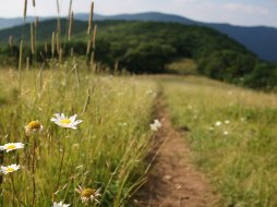
It is said that Graveyard Fields got it's name when a "tremendous wind blow" occurred more than 500 years ago and uprooted the Spruce forest. Over the years the the remaining root stumps and trees rotted leaving behind dirt mounds that resembled a graveyard, and the area has been known as Graveyard Fields ever since. The forest eventually recovered only to be destroyed by a catastrophic fire in 1925. This fire consumed the forest and the ancient mounds. What you see today is the forest slowly recovering. The 1925 fire burned deeply destroying the soil's nutrients slowing the recovery even more. That is the reason that today you get a field-like area that is a "Graveyard Fields."
Our suggestion would be to take at least a half day here to take in the area. We suggest 2 hiking optons within the area.
The first and shortest is to "Second Falls." Take the right set of stairs down from the parking lot (along the paved path) to Yellowstone Prong (creek). Go over the bridge and take an immediate right and in approx. 50 ft. you'll see a sign for "Mountains to Sea (trail") and "Lower Falls." Follow this trail for approx. 0.1 mile to a set of steps (approx. 60) to a viewing platform below (avoiding the side trail along the way). For the return hike simply backtrack to the parking lot.
The second and longer of the two hikes is for both waterfalls and the fields. Follow directions for the first hike except that on your return hike stay to the right side of the creek and head towards "Upper Falls" and through the fields for 1.4 miles. When finished at Upper Falls, backtrack until you come to the first bridge on your right. Take this trail (Upper Falls Trail) back to the parking lot, completing your loop hike.
We also suggest that you pack a picnic lunch with a blanket to spread in a nice grassy area or even creekside on some rocks with the kids. Splash around in Yellowstone Prong (the creek that bisects the loop trail) or go for a swim in the deep pool below Second Falls. If you come in the late Spring you will enjoy the blooming of Rhododendrons, Mtn. Laurels and Flame Azeleas.
Things to bring along on your journey: camera, binoculars, extra clothes/shoes, food supplies and a desire to explore.
Note: There is a third waterfall below Second Falls called Yellowstone Falls. Be advised that the ascent to these falls is extremely steep and dangerous. We do not recommend attempting this climb.
The Local Directions
From Dillsboro/Sylva take US Hwy 74/23 (Great Smoky Mountains Expressway) East towards Waynesville/Asheville. From Exit 85 just outside of Sylva travel 9 miles to the Blue Ridge Parkway Access on the Left. Continue through the Parkway gates and up the hill for 0.5 mile to a split in the road. Go Left towards Asheville for 25.7 miles to the overlook parking on your Left.


