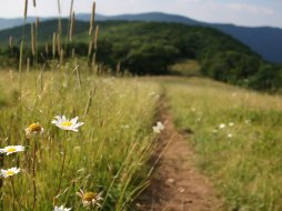
Riding Ford Trail #450
Categories: Play, Hiking & Backpacking, Mountain Biking, Horseback Riding, Backcountry Camping, Hikes to waterfalls, Dog Friendly Hiking Trails, Panthertown Valley Bike Trails, Back Country Horse Trails, Panthertown Valley
Highlights
- Short connector trail between Devil's Elbow Trail #448 and Powerline Road Trail #451
- Crosses the powerline "cut" that was made through the valley by the power company
- Multiple trail combinations nearby
- 3 Waterfalls near the East trailhead including "Riding Ford Falls"
The Local Scoop
Riding Ford Trail #450 is another short connector trail that is just under 1 mile in length. It connects the Devil's Elbow Trail #448 and the Powerline Road Trail #451. We recommend using this trail during a day's ride that involves multiple trails in the valley. We would start out at the suggested East Entrance to the valley. Take Panthertown Valley Trail #474 to Devil's Elbow Trail # 448 (described in more detial in local directions). After taking in the 2 waterfalls off of DET #448 (Warden's Falls & Jawbone Falls, Left side of trail) you'll see a fork in the trail. Take the Left fork onto Riding Ford Trail #450 where you'll cross the Tuckasegee River's headwaters and be at the 3rd waterfall on your ride, Riding Ford Falls. After a little while connect with the Powerline Road Trail. From here, either go Left and under Blackrock Mountain's summit and down towards Panthertown Creek/Tuckasegee River or go Right towards the Northern trails like Rattlesnake Knob #452 or connect with Blackrock Trail #447 and head towards the West Entrance of the valley. You really can't go wrong with the exception of taking side trails. DO NOT take side trails but stick to the main trails mentioned here and you'll be fine. Be aware of the trail designations and download our map for determining this. Some trail aren't bike accessible so be aware of these. NOTE: We recommend researching the Panthertown Valley area before coming and also suggest not coming by yourself or without a map. This area is "wild" and the trail system is unmarked, you can get lost very easily if you don't know where you're going. Our best suggestion is to download and print the map we provide on this site, find the trail(s) you are interested in and plan out your day accordingly. You need to avoid any side trails you come across (and you'll come across a lot of them).
The Local Directions
From the main intersection of U.S. Hwy 64 and N.C. Hwy 107 in Cashiers, N.C. take Hwy 64 East (towards Brevard) for 12.7 miles. Here, take N.C. Hwy-281 North for 0.9 mile to Cold Mountain Road on your Left. Stay on Cold Mountain Road for another 5.9 miles bearing Left the entire way passing other intersections along the way. When you see the sign for Panthertown Valley (bearing left) the road turns to gravel. Travel approx. 0.2 mile to a Right into the access road, parking area, info kiosk and trailheads. The gravel road continues up past this right but there is a sign saying not to go past the gate per Lake Toxaway POA. The access road had a large mud puddle that took the entire road up and was fairly deep. A clearance of approx. 12 inches would have been required. To pick up the Riding Ford Trail #450 start out on Panthertown Valley Trail #474 from the main parking area. At approx. 1.2 miles you'll come to the trailhead for Devil's Elbow Trail #448 on your Right and just before you cross Greenland Creek. If you have crossed the creek you have gone too far. Take this trail for approx. 1 mile to a split in the trail. Take the Left spur onto the Riding Ford Trail #450.
- Coordinates
- 35.173791, -83.002439
- Access
- Moderate/Difficult via either
Powerline Road Trail #451 &
Devils Elbow Trail #448 - Hike Distance
- 1 mile (connector trail)
- Nearest City
- Cashiers
- County
- Jackson County
- Distance From
- East Parking Area for Panthertown Valley, 2 miles
Cashiers, 21.9 miles


