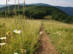
Siler Bald #1
Categories: Hiking & Backpacking, Picnic Areas, Backcountry Camping, Appalachian Trail, Our Favorites
Highlights
- Shorter of the two access routes
- Family friendly, please keep dogs on leash
- Segment of the Appalachian Trail w/gradual ascent
- Excellent "almost" 360 degree views of the southern Nantahala Mtns
- Bald is very large grassy area w/wildflowers in Spring & Summer months
- Excellent place for a picnic or primitive campsite
- Medium length hike (Allow for 2.5 - 3 hours to enjoy)
- Elevation 5,216 Ft.
The Local Scoop
Siler Bald is one of our favorite hikes and you'll be hard pressed to find someone that disagrees who has been to the summit. This moderately difficult hike takes you along one of the predominat ridgelines of the Nantahala Mountains and up from Wayah Gap/Wayah Crest to an elevation of 5,216 feet at the top. We recommend driving to Wayah Bald & Tower before you start your hike to Siler Bald, if you have time that is. From the tower you can see Siler Bald very easily and to the South. Being able to see the grassy bald from Wayah Bald will give you a great sense of geographic location once you're at Siler Bald's grassy summit. Once at the top you'll appreciate and become to accept this summit as one of the best views available in our area. Speaking of views, the near 360 degree views are tremendous. Be sure to take your binoculars and camera along with you to enhance your hike. While at the summit, look to the North on a clear day to see the lookout tower at Wayah Bald (where you were earlier if you had/took the time) and the Radio/TV towers of Wine Spring Bald. Look to the West to see a small portion of Nantahala Lake, Snowbird and Chilhowee Mountains. Looking South you can see Standing Indian Mtn., Albert Mtn. and on into Georgia. Looking East see into the Franklin area & valley. This route (Siler Bald #1) is one of two that are accessible in the Franklin area. See Siler Bald #2 for an alternate route to the summit, both via the Appalachian Trail. However, we recommend this shorter route (Siler Bald #1) to families with smaller children and those looking to spend half the time on the trail as you would with Siler Bald #2. We might also suggest packing a picnic lunch from one of the fine eatery establishments in the Franklin area that are offered on our site. You can either have a picnic at the Wayah Bald area, Wayah Crest (trailhead) area or even better, plan to have your picnic at the summit, for an "almost mile-high lunch." Enjoy one of our favorites!
The Local Directions
From intersection of U.S. Hwy-64 W and U.S. Hwy-23/441 North in Franklin take Hwy-64 W towards Murphy, NC for 3.8 miles to "Old Murphy Rd.(SR 1448) on your Right (Wayah Bald Sign). After you take the exit, continue down the hill for just under 0.2 miles to Wayah Road (SR 1310) on your Left ("Loafers Glory" gas station will be at the intersection of Old Murphy Rd. and Wayah Rd, so you'll know where to turn). Continue on Wayah Rd. for 9.1 miles where you'll find yourself at FR (Forest Road) #69 on the Right, at Wayah Gap. Now, look to the Left and you'll see a road on your Left as you just pass FR #69. Take this road for about 0.2 mi. to "Wayah Crest". This used to be a campground, but is now just a picnic area. Pick up the White Blazed "Appalachian Trail" here. Take the "AT" for 1.6 miles to a clearing. From here you can catch a glimpse of the summit and bald area. It's just a short distance on from here and to get back to your car simply return the same way you came.


