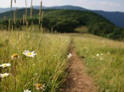
Tsali Trail- Right & Left Loops
Categories: Mountain Biking, Horseback Riding, Tsali Recreation Area Biking Trails, Back Country Horse Trails, Tsali Recreation Area
Highlights
- Excellent mountain biking, horseback riding and hiking trails along the South shore of Fontana Lake and facing the NC side of Great Smoky Mountains National Park
- The 'easiest' two trails of the four main trail systems within Tsali Recreation Area (Tsali Trails Right & Left, Thompson Loop Trail & Mouse Branch Loop Trail)
- Great Fontana Lake & Great Smoky Mountains National Park views along both trails
- 'Single Track' riding at it's best
- Nearby Tsali Campground, Lemmons Branch Boat Access, Tsali Road Boat Access, Area Information, Restrooms & Showers
- Pit Toilets, Water, Information, Pay Area located at trail head
Tsali Recreation Area- Tsali Trail Right/Left Loops & Parking
The Local Scoop
Tsali Trails Right & Left Loops are great trails for mountain biking, horseback riding and hiking. These two trails are rated as 'easy' and offer views of Great Smoky Mountains National Park and Fontana Lake, with a great overlook opportunity of both the park and lake via the Tsali Trail Left Loop.
We highly recommend Tsali Recreation Area and Tsali Trails Right & Left Loops to all mountain bikers and horseback riders in particular. This area is surrounded by natural beauty and is secluded which provides a relaxing getaway.
We also recommend staying a night or two at the Tsali Campground located just steps away from the main parking area for the Right & Left Loops.
If you're into mountain biking, horseback riding, camping, hiking, fishing and boating, Tsali Recreation Area is your ultimate playground. Come give it a shot! You will not regret it!
The Local Directions
From Bryson City, NC
Take U.S. Highway 74 West*/U.S. Hwy 19 West*/N.C. Hwy 28 North* (Great Smoky Mountain Expressway) for 8.3 miles to a right towards Robbinsville on N.C. Hwy 28 North. Continue on (crossing a bridge over Fontana Lake & into 'Graham Co.') for another 3.6 miles to another right onto 'Tsali Road.' Travel down this curvy little road for another 2.5 miles until you reach Tsali Recreation Area.
Horseback parking is to your left (think 10:00 o'clock) and Mountain Bike parking is to your slight left (think 11:00 o'clock).


