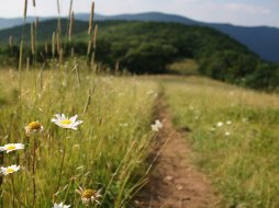
Upper Forney Creek & Trail
Categories: Play, Hiking & Backpacking, Fishing, Backcountry Camping, Fishing for Wild Trout, Great Smoky Mountains National Park... NC
Highlights
- Access via Clingmans Dome parking area just to the left of the Clingmans Dome Trailhead
- Secluded headwaters of Forney Creek offer a journey for native Brook Trout and a cascade to enjoy
- Nearby hiking on the "A.T." Appalachian Trail, Andrews Bald (Forney Ridge Trail) & Clingmans Dome Trail
- 5 primitive campsites (68,69,70, 71 & 74) along entire trail (#71 requires reservation)
- 3 of 5 campsites are located on the upper end (#'s 68,69 & 70) none of which require reservation
- Campsite #68 is a recommended campsite within moderate accessibility of Clingmans Dome parking area
The Local Scoop
If you're like an adventure into Great Smoky Mountains National Park for back country fishing and hiking, then the Forney Creek & Trail is for you. We highly recommend spending some time in this area if you have been in the backcounrty before. You'll need to have basic camping skills, ability to use a compass/map, and you'll need to be with at least one friend. Feel comfortable with those things? Then we suggest giving this trail a shot!
In this Local Scoop I want to focus on the Upper Forney Creek & Trail. My Local Directions will get you to the trailhead that leads you away from the Clingmans Dome parking area. Pick up the "Forney Ridge Trail" and travel for approx. 1.1 miles you'll come to a fork with "Forney Creek Trail" off to the Right. Take this trail down from Forney Ridge to Forney Creek. The trail is rocky as you work your way down the ridge to the creek. The beginning of the trail has recently been renovated byt the 'Trails Forever' program, but be careful and make sure you have the proper shoes, equipment, etc before taking this hike on.
Before you arrive at backcountry campsite #68 you'll need to cross one of the small tributary streams that make up Forney Creek's headwaters. Again, be careful here. Just ahead is campsite #68. There are a couple of nice swimming/wading areas at the creek and paired with the long rock slide it makes for a nice place to cool off on hot Summer days... that is if the temperature ever gets hot enough at this altitude. But if you have been working hard on the trail to get to this point, your body temp might be high enough to brave the very cold waters here. Nevertheless, to me this water is always refreshing! It will take approx. 4-5 hours to really enjoy this trail down to camp #68 on the Forney Creek Trail if you're just hiking in for the day. So if you plan on doing some Brook Trout and Rainbow Trout fishing in Great Smoky Mountains National Park, then our best and most suggested recommendation for this trail is to plan on camping at #68 for the night.
Keep in mind that this is a "non-reservation" campsite and there could be someone else there already. My ultimate suggestion would be to try and get there mid-morning, set up camp then plan on fishing all day by hiking the Forney Creek Trail down as far as you would like, then work your way back up to the camp. That is... if fisihing is your thing!
The Local Directions
From Cherokee, NC take U.S. Hwy-441 North into Great Smoky Mountains National Park. Continue for 20 miles on this curvy two-lane highway to Clingmans Dome Road on your Left. Take this road for a steady 7 mile climb to the parking lot for Clingmans Dome. Pick up the trailhead at the back of the parking area and to the Left of the paved "Clingmans Dome" path. You're looking for "Forney Ridge Trail." Take it for approx.0.5 mile to where the "Forney Creek Trail" forks off to the Right and down.
- Coordinates
- 35.556907, -83.496284
35.540189, -83.515105 - Address
- Cherokee, NC 28719
- County
- Swain County
- Distance From
- FROM (Town): Cherokee, 29.5 miles Hike to Creek: 2.5 miles (one-way) Hike entire trail: 11.2 miles (one-way)
- City
- Cherokee
- Coordinates
- 35.556907, -83.496284


