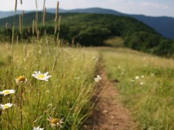
Wasilik Poplar Trail
Categories: Play, Hiking & Backpacking, Kid-Friendly, Museums & Historic Sites, Appalachian Trail, Outdoor Fun
Highlights
- Family Friendly, Senior Friendly, Dogs on Leash
- Well worn path, but watch for exposed roots, they can be dangerous if not paying attention
- Short, but Moderate hike
- 2nd Largest Yellow Poplar in the U.S.
- Tree was topped by Hurricane Opal in 1998
- In 1986 the tree had a 8.4 feet diameter and was 135 ft. tall
- Beautiful canopy of Tulip Poplars in the summer cover the trail illuminating the entire forest
- Recommended hike while staying at Standing Indian Campground
- Suitable for all ages (with exception to toddlers)
The Local Scoop
Come explore one of the largest Tulip Poplars in the entire country, well at one point in it's life. A truly majestic sight to behold and considering the tree is actually dead, it still commands respect while you stand before it imaging it's presence back before it was topped by Hurricane Opal (1998). The hike down to the tree along John Wasilik Poplar trail is one of the most peaceful settings around. You'll climb down to the tree via a well worn path. The forest opens up into a gorgeous "cove-like" area, well shaded by the surrounding Tulip Poplars. You'll even cross a couple of pretty little springs that trickle down the mountain side. Just a little further you'll be at the tree. Enjoy this area as you try to imagine this tree at it's fullest. The girth of the tree's trunk is still a sight to behold. We ask that you please refrain from carving into the tree's trunk, as others have already done.
We recommend that you sit on the small bench at the viewing area and relax in the cool Nantahala Forest breeze. This is an excellent place to hang out at in the woods and one we strongly recommend visiting while in the Franklin area.
After your hike is over, continue on FR 67 for another 1.3 miles to the "Standing Indian Campground" for a nice picnic, swim in the river or for an overnight camp-out under the towering Oaks and stars above. This is where I pretty much grew up during the summers of my adolescent years and still visit to this day. The cool temperatures and ice cold water of the Nantahala River Headwaters (which runs through the campground) makes this spot a great escape from the summer heat in the valley below. So whether you plan on making this trip for the day, or for a week, be sure to explore the Standing Indian Basin area as much as possilbe, for there is lots to do here!
The Local Directions
From intersection of U.S. Hwy-64 W and U.S. Hwy-23/441 North in Franklin take Hwy-64 W towards Murphy, NC for 12 miles. At just before the 12th mile you should see a Brown sign for "Wallace Gap", "Appalachian Trail" & "Standing Indian Campground" with arrows pointing you towards West Old Murphy Road on your left. Stay on W.Old Murphy Rd.(SR 1448) for 2 miles. You'll pass a Nantahala National Forest Sign for the campground saying "500 Ft Ahead", and at 2 miles you'll be at FR (Forest Road) #67 to your Right (indicated by a small, skinny Brown sign at the beginning of the road). Continue on FR 67 for 0.5 miles to parking area on the left. You're at "Rock Gap" and "AT" access. Pick up the John Wasilik Poplar Trail straight ahead (weathered brown sign saying "Wasilik Poplar" is staked at trailhead). You'll see a more prominant "AT" sign at the area, but it says nothing about the Wasilik Poplar Trail.
- Coordinates
- 35.0940, -83.5221
- Access
- Easy via "Old Murphy Rd." &
"Forest Road #67 - Hike Distance
- 1.4 Miles (roundtrip)
- Nearest City
- Franklin
- County
- Macon County
- Distance From
- Standing Indian Campground, 1.3 miles
Franklin, 14.5 miles


