Wilson Lick Ranger Station
Categories: Play, Hiking & Backpacking, Picnic Areas, Museums & Historic Sites, Appalachian Trail, Our Favorites
Highlights
- Historic Info Kiosk telling the history of this area
- Original Ranger Station Structure
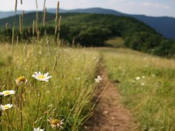
- Meadow-like setting perfect for "blanket-style picnics"
- Nearby walking trail to "Wayah Bald Lookout Tower"
- Nearby Picnic tables at Wayah Bald Tower area
- Fantastic Views North, East and South from Wayah Bald 3.1 miles away
- Appalachian Trail & Bartram Trail access
The Local Scoop
We recommend stopping by Wilson Lick Ranger Station on the way to Wayah Bald Lookout Tower. Built in 1916, the station was used by the watchmen that were commisioned to keep watch over the forest below for fires. Hike the Appalachian Trail to the Wayah Tower like the rangers used to do close to 100 years ago. The hike takes you approx. 3 miles along the "AT" to the summit. There is an info kiosk at this historic site with a nice amount of histroic info about the station as well as the Wayah Tower.
Dating back to approx. 300 B.C. the Cherokee Indians hunted this "Bald" for food. Enjoy the wildflowers as well as native Rhododendron, Flame Azelea and Mountain Laurel mainly prevalent from May-June. The display of pinks, purples and whites are something to see and for "shutterbugs" they offer a days full of picture taking.
The Local Directions
From intersection of U.S. Hwy-64 W and U.S. Hwy-23/441 North in Franklin take Hwy-64 W towards Murphy, NC for 3.8 miles to "Old Murphy Rd.(SR 1448) on your Right (Wayah Bald sign). After you take the exit, continue down the hill for just under 0.2 miles to Wayah Road (SR 1310) on your Left ("Loafers Glory" gas station will be at the intersection of Old Murphy Rd. and Wayah Rd, so you'll know where to turn). Continue on Wayah Rd. for 9.1 miles where you'll find yourself at FR (Forest Road) #69 on the Right, at Wayah Gap. Take this gravel (somewhat rough) road for another 1.3 miles to Historic Ranger Station on your LEFT.


