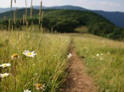
Yellow Mountain Trail and Tower
Categories: Hiking & Backpacking
Highlights
- Challenging hike near Highlands NC
- Stunning 360 degree views from old US Forest Service fire tower
- See: Great Smoky Mountains, Plott Balsam Mtns., Nantahalas, Cowees, Great Balsams & into S.C. & GA.
- Traverse over 4 mountains in under 5 miles (Cole Mtn., Goat Knob, Shortoff Mtn. & Yellow Mountain)
- Highest Peak in the Cowee Mountain Range
The Local Scoop
This hike is strenuous due to it's roller coaster-like trek over 4 mountains in just under 5 miles (4.8 one-way). The 360 degree views from the summit are well worth the hike though. The tower was constructed in 1934 and was staffed until 1969. After it went un-manned it was almost all but lost until the mid-1980's when it went under restoration. Take advantage of Yellow Mountain's central location and views amidst the numerous mountain ranges in WNC like: Great Smoky Mountains, Plott Balsam Mountains, Great Balsams, Nantahalas and Cowees. You can be sure you're looking at the Smokies and the Balsams when you notice the evergreen "firs" of the higher elevations. We highly recommend this hike due to the incredible 360 degree views from the summit, but suggest that you are an experienced hiker due to the elevation changes and strenuous hiking it requires.
Hike Overview
NOTE: No water access on this trail. Bring plenty.
The trail starts out working your way up in elevation and over Cole Mountain from the Buck Creek Road trailhead at Cole Gap. In about a half-mile you'll top out and start heading down slightly. This is your first taste of the roller coaster-like terrain that Yellow Mountain Trail offers. Once you bottom out, you'll begin another climb upwards. This one is a bit longer and a bit more strenuous. Along this climb, you'll hit a series of switchbacks in the trail, as you near the top of Shortoff Mountain. It flattens out a bit at the top, but in no time you'll notice that you're heading down hill again. You're working your way down towards Goat Knob, the third mountain along this route. Down, down, down, you'll go... all the while thinking, "I'm going to have to climb back up this!"
Between Goat Knob and Yellow Mountain Gap, the trail runs into an old Forest Service/logging road, as you head down a bit further into Yellow Mountain Gap. After you bottom out, the final climb to Yellow Mountain's summit of 5,127 feet begins.
Alternate Hiking Option
As you near the top, you'll notice a gravel road to the right of the trail. It actually almost runs into the trail at one point. You have the option of hoppping onto the gravel road for the remainder of your hike. Note: It's MUCH easier than trying to hike through the thick Mountain Laurel thickets near the summit.
A few more thoughts
Take plenty of water. During my last trip in June, it was hot and humid. I ran out of water on my return hike. Bad move.
Wear your best hiking boot/shoe. You'll be hiking along various different surfaces including, rock, sand, leaves, etc.
This hike took me 3 hours and 40 minutes to complete. I went at a fast pace, and only stayed at the summit for 20 minutes.
Plan on anywhere from 4 to 6 hours, depending upon your hiking experience/ability.
The Local Directions
From Franklin
From the intersection of U.S. Hwy-64 East and U.S. Hwy-23/441 North in Franklin take Hwy-64 East towards Highlands, NC for 6.7 miles and take Buck Creek Rd. on your left.
Drive 8.8 miles to Cole Gap and a small parking area on your right, going towards Highlands. The trailhead and sign will be on your left. This is a strenuous hike with a roundtrip total of just under 10 miles (9.8).
From Highlands
From the intersection of U.S. Hwy-64 and N.C. Hwy-28 in downtown Highlands, N.C., travel East on Hwy-64 for approx. 2.8 miles or until you see "Buck Creek Road" on your left, in a prodominant curve. Take this left and travel approx. 2.1 miles to Cole Gap and a small parking area on your left and Trailhead for Yellow Mtn.Trail on your right.


