Smoky Mountains Vacation- Sylva,Bryson City,Franklin,Highlands,Cashiers,Cherokee, NC
Albert Mountain Fire Tower #3
Categories: Hiking & Backpacking, Museums & Historic Sites, Backcountry Camping, Appalachian Trail, Dog Friendly Hiking Trails


Highlights
- Multiple views from just outside of Franklin, NC along the ridge line on the way to Albert Mtn to the East via the Appalachian Trail
- Park at "Mooney Gap" (details in local directions)
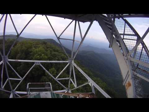
- Excellent Views to the North, East and South from the steps of the tower (Catwalk and enclosed area are locked to public)
- Elevation of 5,210 Ft
- Original Metal Firetower that was built in the 50's to replace an older, wooden tower on nearby Standing Indian Mountain
- Tower was a "live-in" tower at the height of it's use
- To the East and below you is beautiful Coweeta Valley and Otto, NC
- We recommend this route to the more experienced hiker
- Backcountry camping
The Local Scoop
incredible hiking with incredible views, just outside of Franklin, NC. As described in the "Albert Mountain Fire Tower #1" point of interest, this hike is the longer route to the tower. We recommend this route to the more experienced hiker and wouldn't suggest bringing kids along for this one (see our recommendations below). It follows the ridge lines of "Big Butt Mtn" to "Bear Pen Gap" and on up the "Appalachian Trail."
At 2.5 miles, you'll be at the Fire Tower at Albert Mtn. This is a great hike with awesome views to the East. It has some steep parts that will get your blood pumping, but is well worth the journey. You can either make this trip a loop or a return trip.
For the loop.. once you reach the tower, continue on the "AT" past the tower and downhill for about 500 ft. to a side trail on the LEFT that is Blue Blazed. Take this trail for about 0.2 mi. to a parking area and the end of FR #67. Follow this road to the intersection of FR #67 & FR #83. Take FR #83 back to your car at Mooney Gap.
There are a couple different routes one can take to get to the summit, check out my other points of interest named, "Albert Mountain Fire Tower #2", "Albert Mountain Fire Tower #3."
Our recommendations:
For the serious hiker we recommend Albert Mountain #3.
For the historic site seekers and leisurely hikers we recommend Albert Mountain #1.
For the backcountry camper we recommend Albert Mountain #'s 2 &3.
For the pet friendly hiker we recommend #'s 1,2 & 3.
The Local Directions
From intersection of U.S. Hwy-64 W and U.S. Hwy-23/441 North in Franklin take Hwy-64 W towards Murphy, NC for 12 miles. At just before the 12th mile you should see a Brown sign for "Wallace Gap," "Appalachian Trail" & "Standing Indian Campground" with arrows pointing you towards West Old Murphy Road(SR 1448) on your left. Stay on W.Old Murphy Rd. for 2 miles. You'll pass a Nantahala National Forest Sign for the campground saying "500 Ft Ahead," and at 2 miles you'll be at FR (Forest Road) #67 to your right (indicated by a small, skinny Brown sign at the beginning of the road). Continue 1.8 miles on FR 67 until you come to a fork in the road. To your right will be the entrance to "Standing Indian Campground", avoid the right and continue on FR 67 to the left. In about 0.3 miles the road will turn to gravel. Continue on FR #67 past, Hurricane Creek Primitive Campground & Horse Camp, Laurel Falls Trailhead and Mooney Falls Trailhead until you come to another fork in the road at 8 miles from where the pavement turned to gravel at the Backcountry Info Kiosk. This is the intersection of FR #67 and FR #83. Take FR #83 toward Coweeta Hydrological Laboratory (faded grey sign) to the Right for 0.8 mi to where you see the "AT" cross FR #83. Park here and access the trail on the left (North). This is "Mooney Gap."
- Nearest City
- Franklin
- Coordinates
- Trail: 35.03313, -83.46841Summit: 35.05262, -83.477415
- Distance From
- Franklin, 24.7 miles
- County
- Macon County
- Hike Distance
- 2.5 miles roundtrip