 |
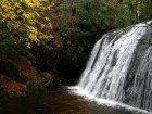
Frolictown FallsCategories: Play, Hiking & Backpacking, Waterfalls, Backcountry Camping, Panthertown Valley, Adventure Waterfalls |
|||||||||||
| ||||||||||||
- Hike3
- Camp4
- Bike2
- Horse1
Highlights
- Small but gorgeous waterfall
- Kid Friendly/Pet Friendly
- Easy hike access along wide "Deep Gap Trail #449"
- Access by hike, bike or horse
- Multiple hiking, camping, fishing and exploring opportunities nearby
- We recommend bringing a blanket/towel to sit on at the base of Frolictown Falls to relax for a while
The Local Scoop
Frolictown Falls aren't the biggest falls in the valley but what they lack in size they make up for in beauty. We suggest this little set of falls to all who love waterfalls like we do. We also recommend pairing this hike up with the Wilderness Falls Trail #490 hike (check the Panthertown Valley map) if you have time, but if not, this short hike is just under 0.9 mile (one-way) by itself, making for a nice afternoon hike for when you're in the area.
From the West Parking Area for Panthertown Valley start out on Panthertown Valley Trail #474 (West) downhill from the iron gate. Use the sign-in box located to the right side of the trail just in case of emergency.
In approx. 10-15 minutes or 0.25 mile you'll come to Salt Rock Gap on your Left. Stop here for tremendous views of the entire Valley in front of you, not to mention the numerous peaks that populate the Valley as well. Continue on down the hill for approx. 0.3 mile to an obvious trail intersection on your right, this is Deep Gap Trail #449. Take this right. You'll hike this trail for 0.3 miles where you'll notice another trail intersection coming into your left. This trail is the Great Wall Trail #489, avoid this trail and stay straight and down towards your right. In just 0.1mile you'll hear Frolictown Falls below the trail on your left. There will be two side trails going down the bank, take the first one, it's the easiest access to the creekside.
When you're finished exploring this area, simply return to the parking area the way you came in. Again, if you feel comfortable with the map we provide in our PDF downloads section, you have a great opportunity to pair this hike up with others in the area.
We would like to suggest taking in Wilderness Falls Trail #490, Frolictown Falls and Granny Burrell Falls. They can be explored within a nice full day-trip experience. Enjoy!
A few recommendations for the hard-core hiker/outdoor enthusiast:
After accessing the Deep Gap Trail #449 from Panthertown Valley Trail #474 (West) and hiking for only a few minutes, be sure to look to you left amongst a large pine thicket. There, you'll see a nice fire ring and an excellent backcountry camping site to stay the night at. Making camp here will put you in an excellent spot to explore the West side of the valley with multiple access trails that lead into other parts of the valley as well. Panthertown Valley offers many of these sites to take advantage of including a couple of backcountry shelters.
Note: We recommend researching the Panthertown Valley area before coming and also suggest not coming by yourself or without a map. This area is "wild" and the trail system is unmarked, you can get lost very easily if you don't know where you're going. Our best suggestion is to download and print the map we provide on this site, find the trail(s) you are interested in and plan out your day accordingly. You need to avoid any side trails you come across (and you'll come across a lot of them).
Local Directions
From the main intersection of U.S. Hwy 64 and N.C. Hwy 107 in Cashiers, N.C. take Hwy 64 East (towards Brevard) for 2 miles to "Cedar Creek Road" on your Left (crossing the Horsepasture River). Take Cedar Creek Road for 2.3 miles to "Breedlove Road" (S.R. 1121 or "State Road") on your Right. There will be a sign for Panthertown Valley at the Stop Sign. Take the Right and travel 3.3 miles to the end of the pavement for Breedlove Rd and where the rough, gravel road begins. You can either park here (if you have a low or nicer car) or you can proceed on rough gravel/mud road to main parking area at entrance to the valley. After you reach the main parking area (via foot- 10 minute walk OR car-0.25 mile) you'll come to a Info Kiosk with a map of the valley in it and a gate across the trailhead. Be sure to take a look at the map and correspond the trails and their #'s with the ones in my local scoop. Finding Panthertown Valley Trail #474 (West) and Deep Gap Trail #449 for this hike.
